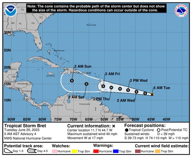
Tropical Storm Bret continues to show signs of strengthening and is expected to become a hurricane within the next day or two as it moves toward the Caribbean Sea, according to the latest advisory from the National Hurricane Center.
While no watches or warnings have been issued as of 5 a.m. Tuesday, forecasters with the National Hurricane Center are advising residents in the Lesser Antilles to monitor the progress of the tropical storm.
Meteorologists are urging residents in Bret’s path to look at the “entire window of movement” and not just the center, especially since it is possible the storm could take not only a westerly path but a “last-minute jog to the north” as it nears the Caribbean, according to AccuWeather Senior Meteorologist Alex Sosnowski.
Low wind shear, which tears budding tropical systems apart, and abnormally warm water temperatures are making conditions favorable for future development.
Bret is the farthest east a tropical storm has formed in the tropical Atlantic — south of 23.5 North — this early in the calendar year on record, according to Colorado State University hurricane meteorologist Philip Klotzbach.
Hurricane/Tropical Storm Bret: What you need to know.
- Location: 1,130 miles east of the southern Windward Islands
- Maximum sustained winds: 40 mph
- Movement: west at 17 mph
- Pressure: 1008 mb
- Next advisory: 11 a.m.
How strong is Tropical Storm Bret and where is it going?
At 5 a.m., the center of Tropical Storm Bret was located 1,130 miles east of the southern Windward Islands. Bret is moving toward the west near 17 mph, and this general motion is expected to continue for the next several days.
If you experience severe loss or damage from this hurricane season, contact an experienced professional at the Insurance Litigation Group (ILG). Our property claim attorneys can get you paid for your loss. We understand that you cannot afford to wait around while the insurer engages in its delaying tactics. ILG is focused on achieving rapid results.


